Scholars like Aristotle, Eratosthenes, and Ptolemy referred to it as Terra Australis Incognita, which means the “Unknown Southern Land” in Latin. During ancient Greece, this mythical continent was believed to exist in a distant corner of the world but remained elusive. Dutch explorer Abel Tasman ventured into the Pacific Ocean in 1642 in pursuit of this mysterious land. He encountered a landmass that would later become known as New Zealand, although it revealed only a fraction of what was believed to be Zealandia.
It took researchers 375 more years to confirm the existence of Zealandia as a submerged continent. A staggering 94% of its landmass lies hidden beneath the ocean’s surface.
Scientists Map Zealandia’s Secrets
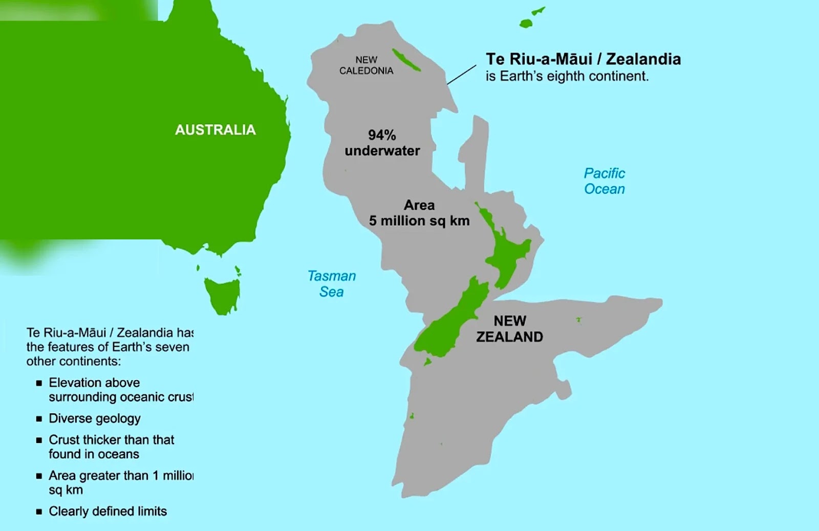
Scientists from GNS Science in New Zealand have published a groundbreaking study in “Tectonics” where they meticulously mapped the boundaries of Zealandia, or as known in the Māori language, Te Riu-a-Mui. This achievement was made possible through the examination of rock samples collected from the seabed.
Zealandia sprawls across an area of over five million square kilometers, and much of its surface remains uncharted. The history of this submerged continent is intertwined with that of Gondwana, the ancient supercontinent that fragmented hundreds of millions of years ago, giving rise to the continents we know today.
Zealandia separated from Gondwana approximately 80 million years ago. However, unlike its neighboring continents, Antarctica and Oceania, much of Zealandia lies submerged beneath the ocean’s depths. The only remaining landmasses on the surface are islands that belong to New Zealand, New Caledonia (a French territory), and Australian-controlled territories like Lord Howe Island and Ball’s Pyramid.
Due to its underwater location, research related to Zealandia has been limited, leading to inconsistencies in defining its shape and boundaries. Until recently, only the southern part of the continent had been mapped.
Completing the Geological Puzzle
Geologist Nick Mortimer led the recent research expedition that has now filled in critical gaps, mapping two-thirds of the submerged continent. The study proudly states, “Geological mapping from combined onshore and offshore field campaigns across the entire ~5 Mkm2 Zealandia is now complete.”
To achieve this, teams of geologists and seismologists analyzed rock and sediment samples collected from the seabed, primarily through drilling, as well as specimens from island shores in the region.
Their findings included sandstone dating back to the Upper Cretaceous period (approximately 95 million years old) containing granite and volcanic gravel from the Lower Cretaceous period (around 130 to 110 million years ago). Basalt from the Eocene era (approximately 40 million years old) was also identified.
This wealth of data, combined with regional magnetic anomaly information and insights from other studies, has enabled scientists to create a detailed map of the underwater geology in the northern part of Zealandia.
A Continent Unveiled: What Has Changed?
The Earth’s continental crust typically extends to a depth of around 40 kilometers, significantly thicker than the oceanic crust, which averages around 10 kilometers. Zealandia’s crust reaches approximately 20 kilometers in depth due to its extensive continental shelf when it separated from Gondwana. Though relatively thin, it never reached the normal thickness of typical oceanic crust.
Scientists argue that, based on its crust’s thickness and the composition of its constituent rocks, Zealandia undeniably qualifies as a continent.
Aside from its scientific significance, defining Zealandia as a new continent carries practical implications. According to the United Nations Convention on the Law of the Sea, countries can extend their jurisdiction beyond the Exclusive Economic Zone (EEZ), which spans 370 kilometers from their coastlines, to claim an “extended continental shelf, including all its mineral and oil resources.”
By establishing that Zealandia is part of a larger continent, New Zealand could potentially expand its territory up to six times its current size. This expansion would significantly affect marine exploration and resource management, leading to a doubling of funds allocated to marine research in recent years.
In essence, Zealandia’s emergence as a recognized continent represents a profound shift in our understanding of Earth’s geological history and has far-reaching implications for oceanic exploration and resource utilization.